READ THIS FIRST:
The geographical data in Harvest is crucial for a good functioning of the system as a whole. Many reports, the maps, and the data entry of churches depend on good geographical data.
In theory you should rarely have to touch this data. This is because Church Cloud Solutions will try to find correct geographical data for your country, including area names, shape files (for the maps) and population data. They are all dependent upon each other.
However, in reality it is sometimes necessary to change the provided data as names may be wrongly spelled, or new villages are founded in your country and it is not possible to wait for the next update from Church Cloud Solutions for your country. In these cases it may be needed to change the data.
Step 1: First you will have to identify the area that needs change. For example, you could look at the Christian Presence map, and notice that the name of an area is wrongly spelled. Or you try to add a church and notice that it is difficult to find the right church location as the area is wrong.
Step 2: Write down the name of the area that needs to be changed (the wrong spelling), or copy it to your clipboard.
Step 3: Open System Setup - Geography.

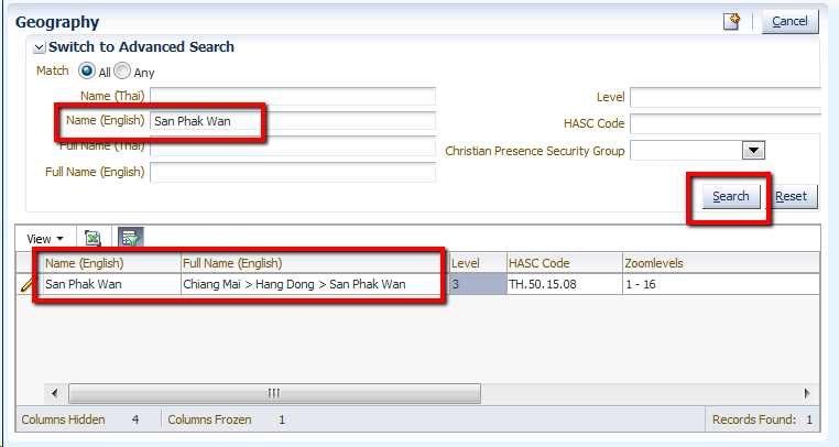
Step 4: Search for the wrongly spelled name, in the correct language:

Step 5: Verify by the Full Name column in the table that you are looking at the right area (is it in the correct province/district)?
Step 6: Click on the pencil icon to edit the record.
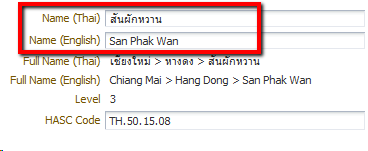
Step 7: Provide the correct name(s) of the area you are looking at:

Step 8: Save your changes.
Preferably, you wait for GlobalRize to update all villages/areas in your country at once. This is for several reasons:
However, for some countries there are no shape files and/or population data available at the lowest levels of detail (like villages). In these cases it is makes more sense to add these areas.
If in doubt, always contact Church Cloud Solutions before starting to add new areas to the system.
In case you are sure that adding an area is OK, here are the steps:
Step 1: Open System Setup - Geography.

Step 2: Identify the area 'above' the one you want to add. For example, if you want to add a village, what is the immediate sub-district (or commune, or whatever it is called) that this belongs to? Now search for that name.
Step 3: Click on the pencil icon to edit that area.
Step 4: In the form that you are presented with, click on the new icon to add a new area as a SUB area of the one you are looking at:

Step 5: You will now have to fill in the form for the new area:

Step 6: Save the new area.
Sometimes an area gets split up into several areas, for example a new province is created by dividing an existing province into two provinces.
The process above explains how to add the new province, but how can one move the regions that are under the 'old' province to the 'new' province?
This process works by changing the HASC code. It is vital that one knows the new HASC code in order to make this work.
Step 1: Look up the area that you want to move in the system, by searching for it's name or the old HASC code.
Step 2: Click on the pencil icon to edit the area.
Step 3: Change the HASC code to reflect the new situation. In the example below, the current HASC code is TH.50.15, which refers to Hang Dong (15) in the province of Chiang Mai (50) in the country of Thailand (TH). So the HASC code is TH.50.15. But now the area is moved to a new province called Utopia (code 99), and the new region code is 17. So you can change the HASC code to TH.99.17.

Step 4: Save the data. The Full Name should be updated to reflect the new situation. This indicated the area is successfully moved to the other province. All churches that are linked to this area (or any of it's subareas) will automatically be moved as well.

This is not possible through the screens. Rather, you (as national coordinator) or Church Cloud Solutions has to find a good source of population data for the whole country, on all levels of detail. Just updating the population data on a national or provincial level may be nice for the first few levels of details on maps, but it creates inconsistencies in reports. For example, the combined population of all districts in a province should match the total population figure for that province. If not, this will create problems for reporting on provincial level.